Ahmedabad, India Wins 2010 Sustainable Transport Award

City’s Janmarg Bus Rapid Transit System Reduces Carbon Emissions, Dramatically Improves Residents Access

Cities in Developing World Dominate Award

WASHINGTON, Jan. 12 /PRNewswire-USNewswire/ — The developing world is leapfrogging developed countries when it comes to urban transport, with the city of Ahmedabad, India, today announced as winner of the 2010 Sustainable Transport Award for the successful implementation of Janmarg, India’s first full bus rapid transit (BRT) system.

“This year’s Sustainable Transport Award nominees demonstrate the relevance of the developing world in the fight against climate change while improving citizen’s quality of life and enhancing their international competitiveness,” said Walter Hook, Executive Director of the Institute for Transportation and Development Policy. “Cities have the power to significantly reduce carbon emissions by actively seeking ways to improve transport.”

The Sustainable Transport Award is given annually to a city that uses transport innovations to increase mobility for all residents, while reducing transportation greenhouse and air pollution emissions and increasing cyclist and pedestrian safety and access.

Ahmedabad’s Janmarg BRT system is a sustainable model for the future of transportation in India, where a quarter of the world’s population lives. “BRT systems can positively impact air quality if car and motorbike drivers start taking trips by bus,” said Sophie Punte, Executive Director of the Clean Air Initiative for Asian Cities (CAI-ASIA). “This is particularly important in Asian cities, where air pollution levels are often far above guidelines of the World Health Organization.”

City residents have embraced their new BRT system; 18,000 daily passengers use Janmarg to commute to work, to school and elsewhere. In just a few months of operation, Janmarg has transformed the delivery of transit in South Asia. Janmarg uses innovative central median stations pulled away from the junctions. Bus stations feature passive solar design, an inexpensive way to keep stations naturally cool. The city is making continued efforts to be a leader in sustainable transport, including incorporating high-quality pedestrian facilities in some corridors, as well as bicycle lanes. Ahmedabad has initiated car-free days and recently announced more.

For the first time in the six-year history of the Sustainable Transport Award, all of the nominees are cities in developing nations. The four honorable mentions go to Cali, Colombia, for transforming citywide BRT service with MIO; Curitiba, Brazil, for opening a new BRT line and city park on a former federal highway; Guadalajara, Mexico, for completing a full BRT system in less than two years and at an affordable cost; and Johannesburg, South Africa, for creating Rea Vaya, Africa’s first BRT and the first public transit system that connects Soweto to the downtown district.

Read More

NAIROBI, Jan 4 (IPS) – In early November, a group of explorers set out to map a blank space in Africa’s map. Twelve youths armed with global positioning system (GPS) devices made the rounds of the Nairobi slum of Kibera.

The teens are working with an organisation called OpenStreetMap to create a public map of their neighbourhood, seven kilometrs southwest of the city centre. It is the second-largest informal settlement in Africa, after South Africa’s Soweto township.

UN-HABITAT estimates its population at 500,000 to 700,000, with a density of more than 2,000 people per hectare. The settlement is divided into 10 villages, Lindi, Soweto (East and West), Makina, Kianda, Mashimoni, Gatuikira, Kisumu Ndogo, Laini Saba and Siranga.

Despite being home to about one million in a densely populated area, Kibera remains a blank spot in Kenya’s map. The area lacks basic services like toilets and running water.

“While Kibera remains a blank spot, its limited health and water resources, traffic patterns, and housing layouts remain largely invisible to the outside world, and to residents themselves,” Mikel Maron of OpenStreetMap explains.

“Though many organisations have collected data on Kibera, the information is not yet shared as a resource for all to use. Map Kibera will fill in this gap by producing free, open-sourced digital map data, using the techniques of OpenStreetMap, a user-edited map of the world. This information can easily be accessed and used by non-governmental organisations and private and public companies working in the area.”

The young mapmakers took part in a two-day workshop on geographic information systems before setting out to map important landmarks within the settlements. These images will then be scanned and placed in the geographic information system (GIS), and later uploaded into the internet and made available to everyone.

They are not qualified surveyors but ordinary youths who have been taught to use GPS technology. Partner organisations in the technology industry will help train and network with the Kibera community on the project.

Maron says the map will point out landmarks such as churches and mosques, schools, businesses, restaurants, the premises of organisations working in the area and government administrative offices. He says the project is not aimed at collecting demographic data, but rather consolidating information on public infrastructure.

“Very little is known about what exactly goes on in the various villages. Indeed, people in Kibera may not be aware of all the facilities available, such as health centres and charitable organisations. The information we will consolidate will help those who wish to access Kibera know exactly where a particular place is, and what kind of service they provide.

“That way it is easy for organisations wishing to work in Kibera to ascertain what extra services may be required,” Maron says.

The project is spearheaded by the humanitarian OpenStreetMap team in collaboration with JumpStart International, and other partners including Jubal Harpster of WhereCampAfrica, the Social Development Network, Pamoja Trust, Hands on Kenya and Carolina for Kibera.

OpenStreetMap creates free editable maps of the whole world, which provide geographical data to anyone who wants them. The maps are uploaded on the internet and can be edited by anyone to provide additional information.

“There has been a general lack of accountability on the projects going on in Kibera. With this kind of information available, it will be easy to know exactly which organisations are working in Kibera, including available services and facilities,” Maron says. Besides mapping, the team will include details of landmarks.

Sheikh Ramadhan, a resident of Kibera, says the area has been turned into a cash cow for organisations claiming to work in the informal settlement, but many would be hard-pressed to show a tangible contribution.

“Kibera is the only informal settlement in this country where we have more than 100 NGOs operating in this small area. But this has done very little to improve the lives of residents, and we still live in mud-corrugated structures with lack of basic facilities such as functional sewer systems and clean water,” Ramadhan says.

Once the map is complete, the raw data will be available at no charge to upload into collaborative mapping platforms, for organisations that may need specific data on the area, including local authority and national government. The map will be updated as conditions change. Maron says it will operate in a way similar to the Wikipedia encyclopaedia, where anyone with additional information can add the data.

“With this kind of knowledge it will be possible to speak from an informed point of view regarding planning of the area in terms of infrastructure. For instance we can flag how many health centres are available, where they are and what needs to be added,” Maron explains.

Dr Siddharth Agarwal, executive director of the Delhi-based Urban Health Research Centre, says that rapid urbanisation and the growth of slum settlements poses a serious challenge to city planning. He says that in most of the world, including his native India, the majority of these areas remain. Spatial mapping, in his view, has not been used optimally for city planning to provide basic facilities such as health and sanitation.

“One of the main obstacles to effective urban planning is a lack of up-to-date, comprehensive and sufficiently detailed information about urban areas. This lack of information is a major reason behind the failure of urban municipalities to include informal settlements in city-wide planning and urban development,” Agarwal said.

In the absence of information about and understanding of slums, these settlements were typically considered to be chaotic masses rather than coherent urban areas, and thus are ignored or subject to planning aimed at them as slums to be eradicated rather than understood as an integral part of the city.

Source – http://www.ipsnews.net/africa/nota.asp?idnews=49883
We are pleased to publish two reports on climate change and health in urban settings. The first is a study of how rising temperatures will affect vulnerable people in urban environments, with a case study about work ability on hot days in New Delhi, India
http://www.who.or.jp/2009/reports/Technical_report_work_ability_09.pdf

The second is a review of dengue fever, a vector-borne disease spreading due to the warming climate. This includes a case study from Bangkok.  
http://www.who.or.jp/2009/reports/Technical_Report_BKK_case_study_09.pdf 

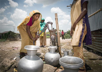
In Karachi, Pakistan, the majority of citizens suffer from poor levels of water and sanitation services, especially those in low-income settlements. To help them create a plan to improve their services, the Karachi City District Government formed a partnership with the Water and Sanitation Program (WSP).

The partners began by giving citizens an opportunity to ‘grade’ the performance of the Karachi Water and Sewerage Board (KWSB) using ‘citizen report cards‘. This method was piloted in Bangalore by the Public Affairs Centre in 1993 and has proven to be a demand-responsive,  positive force for change, not just in Bangalore, but internationally.

Asking customers to grade the performance of the utility provided the Karachi government with neutral, credible and apolitical information on consumer preferences and concerns surrounding water supply and sanitation services.

“The report card has provided us information about those areas which we considered as outside the coverage of KWSB” said Ayub Shaikh a staff member of the Karachi Water and Sewerage Board.

Nearly 5,000 men and women in nine towns in Karachi representing low, middle, and high income groups were asked to grade the utility. Women are generally involved in accessing water for their familieswhile men typically bear the cost of services.

The partners launched a communications strategy early in the process to make sure the findings of the report card were broadly disseminated to increase and encourage public debate. They turned to PANOS, a global program created to engage the media and increase public debate through training, orientation, and opportunities for understanding and learning.

The communications program was designed to build a partnership between the government and the media to build awareness of civic rights and responsibilities, highlight the need for reform, and most importantly create a constituency that has a loud voice so their demands can be heard for improvement of services.

Read More

Climate change and the urban poor. Risk and resilience in 15 of the world’s most vulnerable cities
IIED, CLACC – Dec 2009.

Full-text – http://www.iied.org/pubs/pdfs/G02597.pdf (pdf, 1.7MB)

Areas: Mozambique, Tanzania, Kenya, Bangladesh, Benin, Mauritania, Senegal, Mali, Sudan, Nepal, Zimbabwe, Uganda, Zambia, Malawi

This report outlines lessons learnt regarding the principal effects of climate change on 15 cities in low-income countries, and what makes them vulnerable to these effects. Coastal cities are susceptible to a rise in sea level and are made vulnerable by the low-lying land they are often built on, while dryland cities suffer from scarce water resources due to extended periods of climate change-induced drought. In these and other inland cities, the level of poverty, the rapid pace of urbanization and a lack of education about climate change increase vulnerability and aggravate the effects of climate change. Innovative urban policies and practices have shown that adaptation to some of these effects is possible and can be built into development plans. These include community-based initiatives led by organizations formed by the urban poor, and local governments working in partnership with their low-income populations.

Journal of Urban Health: Bulletin of the New York Academy of Medicine, doi:10.1007/s11524-009-9411-2

Mixing Urban Health Research Methods for Best Fit

Full-text:  http://www.springerlink.com/content/l74j17579t31710h/fulltext.pdf

Evelyne de Leeuw

In many domains, diversity is attractive; whether we look at urban planning and aesthetics, political or culinary smorgasbords, access to health service and entertainment facilities, or opportunities for connectedness, a greater variety tends to relate to more choice for well-being and fulfillment. A landmark study that eventually led to the emerging discipline of social neuroscience found a dose response relationship between the diversity of social ties people engage in and their susceptibility to infectious disease. Similarly, it is postulated that such a relationship might exist between urban aesthetics, physical activity, and health.

 J Water Health. 2010 Mar; 8(1):184-91.

Social-epidemiological study for evaluation of water supply and sanitation systems of low-income urban community in Dhaka, Bangladesh.

Mollah KA, Aramaki T. Natural, Biotic and Social Environmental Engineering, Interdisciplinary Graduate School of Medicine and Engineering, University of Yamanashi, 4-3-11 Takeda, Kofu Yamanashi, 400-8511, Japan Tel.:/Fax: +81-55-220-8592 E-mail: kabirulmolla@yahoo.com.

This study aims at quantification of health losses, considering social and environmental factors.  Morbidity and mortality cases of diarrhoea for children under five years old were used to estimate the disability adjusted life years (DALYs) lost for the target households in low-income communities in Dhaka, Bangladesh.  Water supply facilities and sanitation systems, along with hygiene practices and their health outcomes, were studied at community level.

Demographic, socio-economic and socio-cultural aspects were also studied to support the research findings and give a better understanding of the local conditions. The four selected communities, Ward 60 (W60), Ward 61 (W61), Ward 62 (W62) and Ward 65 (W65), all had different existing urban services such as water supply, sanitation, garbage management and drainage facilities.

All of these services existed in W62, but W60 did not have any of the services; W61 had sanitation and drainage coverage, whereas W65 had only a water supply facility. The results conclusively showed that, compared with the null (absence of services) scenario (W60), the other three scenarios (W61, W62 and W65) showed a substantial decrease of diarrhoea (1.219, 1.284 and 2.052 DALYs/household/year, respectively) reported for children under five years old. Besides urban services, other socio-economic characteristics might also influence the prevalence of diseases.

J Nutr. 2010 Jan;140(1):195S-200S.

Higher household expenditure on animal-source and nongrain foods lowers the risk of stunting among children 0-59 months old in indonesia: implications of rising food prices.

Sari M, de Pee S, Bloem MW, Sun K, Thorne-Lyman AL, Moench-Pfanner R, Akhter N, Kraemer K, Semba RD.

Helen Keller International, New York, NY 10010, USA. msari@unicef.org

Because the global financial crisis and high food prices affect food consumption, we characterized the relationship between stunting and nongrain food expenditure at the household level among children 0-59 mo old in Indonesia’s rural and urban poor population. Expenditure and height-for-age data were obtained from a population-based sample of 446,473 children in rural and 143,807 in urban poor areas in Indonesia. Expenditure on food was grouped into categories: animal, plant, total nongrain, and grain. The prevalence of stunting in rural and urban poor areas was 33.8 and 31.2%, respectively. In rural areas, the odds ratios (OR) (5th vs. first quintile) for stunting were similar for proportion of household expenditure on animal (0.87; 95% CI = 0.85-0.90; P < 0.0001), plant (0.86; 95% CI
= 0.84-0.88; P < 0.0001), and total nongrain (0.85; 95% CI = 0.83-0.87; P < 0.0001). In urban poor areas, the relationship between stunting and proportion of household expenditure on animal sources was stronger than in rural areas (OR 0.78; 95% CI = 0.74-0.81; P < 0.0001), whereas the relationship with nongrain was similar to rural areas (OR 0.88; 95% CI = 0.85-0.92; P < 0.0001) and no relationship was observed with plant sources (OR 0.97; 95% CI = 0.93-1.01; P = 0.13). For grain expenditure, OR for stunting in highest vs. lowest quintile was 1.21 (95% CI = 1.18-1.24; P < 0.0001) in rural and 1.09 (95%CI = 1.04-1.13; P < 0.0001) in urban poor areas. Thus, households that spent a greater proportion on nongrain foods, in particular animal source foods, had a lower prevalence of child stunting. This suggests potential increased risk of malnutrition associated with reductions of household expenditure due to the current global crises.

30 December 2009 – Ministry Public Relations Directorate Director, Ahmed Imano, said at a consultative forum organized to health experts on ways of implementing urban health extension program that efforts are being made to deploy over 5,000 health extension workers in urban areas.  He said some 3, 749 health extension workers are being trained so as to attain the set target.  He finally called on all health professionals and pertinent bodies to contribute share for the efficient realization of the program. Ministry Disease Prevention and Health Development Directorate Officer, Abate Benti, on his part called on the public to take active part in the program in order to repeat the results attained in rural areas in urban areas as well.

He said implementation manual and curriculum have been distributed for the efficient implementation of the program. Some 722 health extension workers have already been deployed in Addis Ababa, he said, adding 773 of the 1, 468 recruited nurses are also receiving training. He further said training of trainers (ToT) has been offered to 100 health professional drawn from Harari, Amhara, Tigray, SNNP and Oromia states as well as Dire Dawa and Addis Ababa administrations. Health professionals drawn from the Ministry of Health, Addis Ababa health bureau and pertinent bodies attended the half-day consultative forum organized jointly by Walta Information Center and Ministry of Health.

Dec. 17, 2009 – More than half of Delhi’s population lives in urban slums with inadequate provision of basic services, a study released here Thursday said. According to the study, titled ‘A situational analysis of the young child in India’, 52 percent of Delhi’s population resides in urban slums. The survey, conducted in six slums in Delhi by Forces, a voluntary organisation working on child care services in India, shows that in comparison to Delhi’s infant mortality rate (IMR) of 40, the IMR in slums is higher at 54 for every 1,000 live births. 

The immunisation level in the slums covers 34 percent of the population and because of the negligence of civic authorities in providing safe drinking water and sanitation, there is a high incidence of diseases such as diarrhoea (75 percent) and anaemia (63 percent). ‘The nutritional status of the urban poor in Delhi is a matter of concern. Delhi has 35.4 percent stunted, 15.5 percent wasted and 33.1 percent underweight children under the age of three despite being a state with the second highest per capita income in India,’ the report said.

The report goes on to say that 31 percent of Delhi’s slumdwellers has no sanitation facilities and no underground sewage system. On the plight of construction workers, the report says that 67 percent children and 69 percent women construction workers are undernourished. The report suggested: ‘The focus on quality health services has to be accompanied by a clear policy of land allocation for health services in Delhi’s master plan. The current allocation shows a decreased allocation of space for primary health centres in urban poor settlements’.

Amod Kanth, chairman of the Delhi Commission for Protection of Child Rights (DCPCR) who was present at the report’s release at the India International Centre, said that more focus should be given to increasing the number of service providers. ‘We need more skilled man power to handle our health services. That is key to proper implementation of the health services to the people,’ he said.

Source – Sify